World's Tallest Tsunami, world record in Lituya Bay, Alaska
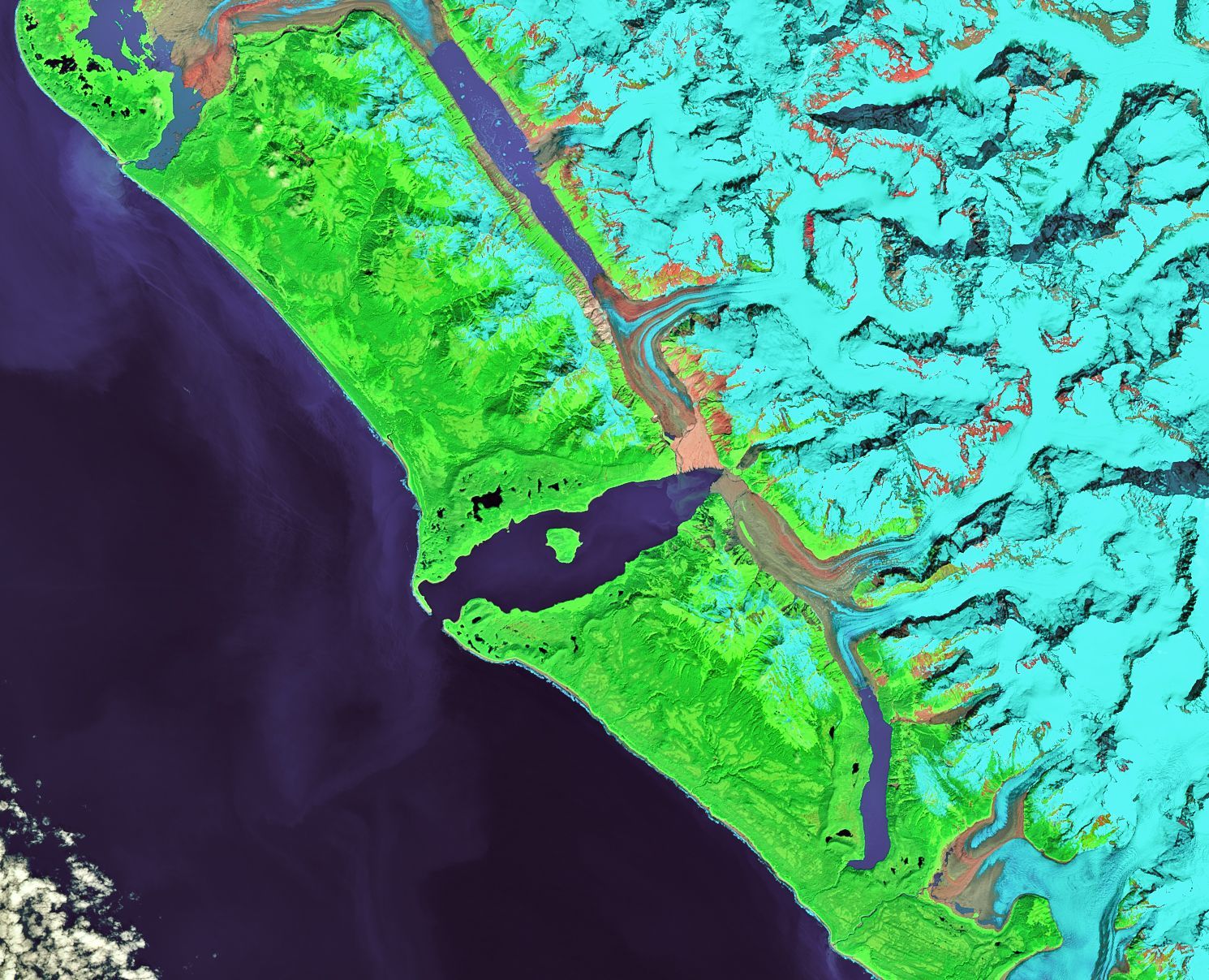
Lituya Bay, Alaska, United States--On July 10, 1958, a magnitude 7.7 earthquake occurred on the Fairweather Fault in southeast Alaska; it caused significant geologic changes in the region, including areas that experienced uplift and subsidence; it also caused a rockfall in Lituya Bay that generated a wave with a maximum height of 1,720 feet, which sets the world record for the World's Tallest Tsunami, according to the WORLD RECORD ACADEMY.
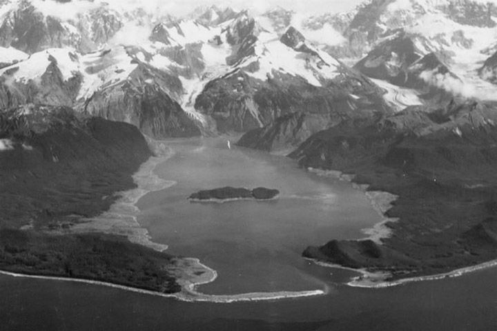
"On July 10, 1958, a magnitude 7.7 earthquake occurred on the Fairweather Fault in southeast Alaska. It caused significant geologic changes in the region, including areas that experienced uplift and subsidence. It also caused a rockfall in Lituya Bay that generated a wave with a maximum height of 1,720 feet – the world’s largest recorded tsunami," the Western States Seismic Policy Council says.
"A total of five people were killed in the event: three people died on Khantaak Island at the mouth of Yakutat Bay when the beach they were standing on subsided 100 feet below sea level; the other two died when their boat was sunk by the tsunami at Lituya Bay.
"Scientists were puzzled for some time by the sheer size of the wave, because they could not identify a mechanism that could have created such a massive reaction. Ultimately, it was discovered that a piece of rock, 2,400 feet by 3,000 feet, and 300 feet thick, had dislodged from the face of the northern wall of the inlet, and fallen 2,000 feet into the bay. In some respects, it created a similar reaction to that which would have occurred if an asteroid had fallen into the water."
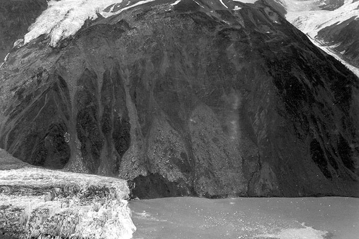
"On the night of July 9, 1958, an earthquake along the Fairweather Fault in the Alaska Panhandle loosened about 40 million cubic yards (30.6 million cubic meters) of rock high above the northeastern shore of Lituya Bay," the Geology.com says.
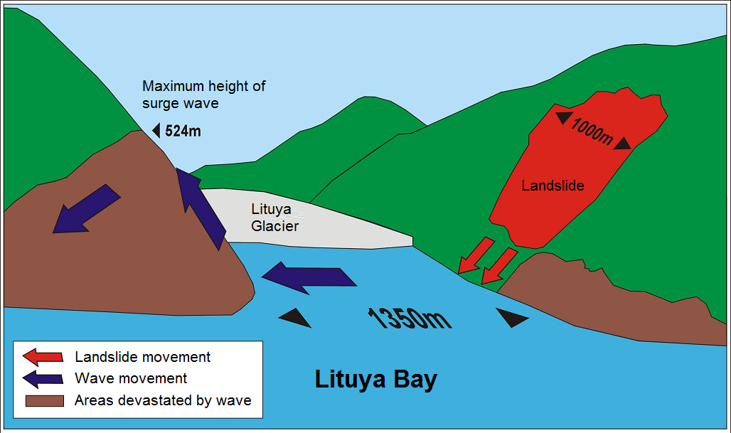
"This mass of rock plunged from an altitude of approximately 3000 feet (914 meters) down into the waters of Gilbert Inlet (see map below). The impact force of the rockfall generated a local tsunami that crashed against the southwest shoreline of Gilbert Inlet.
"The wave hit with such power that it swept completely over the spur of land that separates Gilbert Inlet from the main body of Lituya Bay. The wave then continued down the entire length of Lituya Bay, over La Chaussee Spit and into the Gulf of Alaska. The force of the wave removed all trees and vegetation from elevations as high as 1720 feet (524 meters) above sea level. Millions of trees were uprooted and swept away by the wave. This is the highest runup ever recorded for a tsunami."
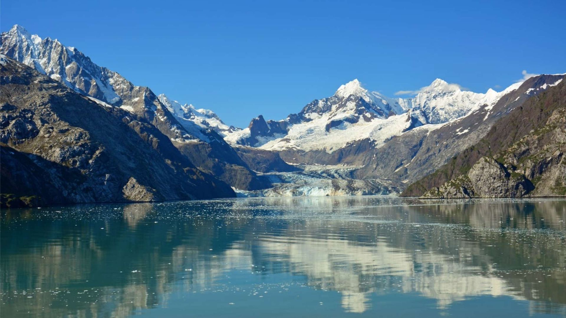
"The 1958 Lituya Bay earthquake occurred on July 9, 1958 at 22:15:58 PST with a moment magnitude of 7.8 to 8.3 and a maximum Mercalli intensity of XI (Extreme). The strike-slip earthquake took place on the Fairweather Fault and triggered a rockslide of 30 million cubic meters (40 million cubic yards) and about 90 million tons into the narrow inlet of Lituya Bay, Alaska.
"The impact was heard 80 kilometers (50 mi) away, and the sudden displacement of water resulted in a megatsunami that washed out trees to a maximum elevation of 524 meters (1,719 feet) at the entrance of Gilbert Inlet. This is the largest and most significant megatsunami in modern times; it forced a re-evaluation of large-wave events and the recognition of impact events, rockfalls, and landslides as causes of very large waves," the Wikipedia says.
"The Lituya Bay tsunami caused damage at higher elevations than any other tsunami, being powerful enough to push water up the tree covered slopes of the fjord with enough force to clear trees to a reported height of 524 m (1,719 ft). A total of 5 people were killed during the tsunami, which left many people injured and many homes destroyed. Two people from a fishing boat died as a result of being caught by a wave in the bay. Two more individuals, a fishing boat captain and his seven-year-old son, were struck by the wave and lifted hundreds of feet into the air by the swell. Remarkably, both survived with minimal injuries."
"He said it is important to be prepared and know the natural warning signs of earthquakes, landslides, and tsunamis. He said people should also be prepared for the worst because Alaska has seen the worst before. The massive 1958 tsunami wasn’t the first time a large wave was created in Lituya Bay. It has happened multiple times before," the
Alaska's News Source says.
"There are indications of four other instances stretching from the mid-1800s to the mid-1900s — though the 1958 wave is the largest scientists have found. Eyewitness accounts and evidence from the grounds around Lituya Bay indicate there were disastrous large waves in 1853 or 1854, and again in 1874, 1899, and 1936.
"The combination of the geologic factors in the area, including the fault, the potential for major rainstorms to trigger landslides, and the deep fjord land water in Lituya Bay make the chances of another tsunami very likely, Salisbury said. Any steep slope and glaciated terrain in Alaska and around the world can be very dangerous. “Understanding that maybe staying away completely is not possible, I would tell folks to be aware of the natural warning signs of large earthquakes and or landslides.”
"Eyewitness reports describe a chaotic and surreal scene: Intense shaking for several minutes, an explosive boom, and a shattered glacier soaring hundreds of feet into the air. Then a series of giant waves dotted with hunks of ice raced through the bay. One fisherman described his boat being lofted over a forested spit on the crest of one wave and looking down at trees below. The wave obliterated a cabin on Cenotaph island and swept away a lighthouse near the mouth of the bay. One couple that had been fishing when the wave hit were never heard from again," the
NASA Earth Observatory says.
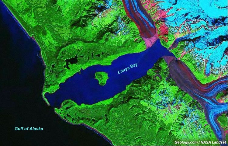
"The damage line in the forest—geologists call it a trimline—generally extended to an elevation of 700 feet (200 meters) around much of the bay. On one ridge opposite the slide, waves splashed up to an elevation of 1,720 feet (524 meters)—taller than New York’s Empire State Building. The event at Lituya Bay still stands as one of the tallest tsunami waves known to science. The photo above, taken in 1958 after the tsunami, shows the ring of damage around much of the bay.
"Evidence of the cataclysmic wave is still visible from space more than 60 years later. As seen in the false-color Landsat 8 image (bands 7-5-3) at the top of the page, the damaged trimline is still imprinted in the forest. The lighter green areas along the shore indicate places where forests are younger than older trees (darker areas) that were not affected by the tsunami. When the tsunami hit, it snapped all of the trees and scoured away almost all vegetation. Some 2 square miles (4 square kilometers) of forest were sheared and swept away by the tsunami waves."
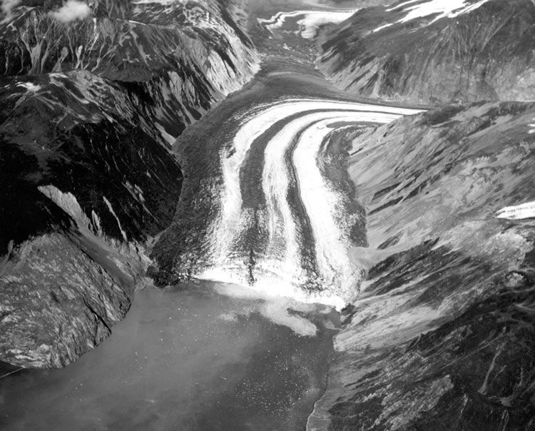
"Lituya Bay is a seven-mile long, two-mile wide fjord on the southeast coastline of Alaska, roughly a hundred miles southeast of Yakutat. The name derives from the Tlingit Ltu.aa, meaning “lake within the point.” The bay has been the site of several previous giant waves and tragedies. The most notable pre-1958 incidents involved the French scientific expedition dispatched by King Louis XVI and led by Jean François de Galaup, Comte de Lapérouse," the Alaska Dispatch News says.
"On July 9, 1958, around 10:15 p.m., a 7.8 magnitude earthquake struck, centered near Lituya Bay. Three boats were anchored in the bay: the Badger with Bill and Vivian Swanson aboard, the Edrie with Howard Ulrich and seven-year-old Sonny (Howard Ulrich Jr.), and the Sunmore with Orville and Mickey Wagner.
"The earthquake prompted a massive rockslide. An estimated 40 million cubic yards of mostly intact stone slid hundreds of feet before crashing into the water. The resultant wave was not just a tsunami but the largest tsunami ever recorded, a megatsunami. At an estimated 1,720 feet high at its highest, it would have dwarfed every building in Anchorage. The second largest recorded tsunami surprisingly happened inland, in Washington."

"Tsunamis generally reach a maximum vertical height onshore, called a run-up height, of no more than 100 feet above sea level. A notable exception was the 1958 tsunami triggered by a landslide in a narrow bay on Alaska's coast," the PBS says.
"Its over 1,700-foot wave was the largest ever recorded for a tsunami. It inundated five square miles of land and cleared hundreds of thousands of trees. Remarkably, only two fatalities occurred.
"In the wake of the Lituya tsunami, scientists realized for the first time that a landslide—90 million tons of rock in the case of Lituya—could produce a giant wave."
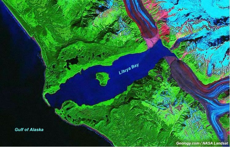
"On July 9, 1958, an earthquake with an estimated magnitude of 7.7-8.3 triggered an enormous rockfall in a remote bay along the Gulf of Alaska. The seven miles long and two miles narrow Lituya Bay was protected from waves by two promontories, separating it from the open sea, and a popular fishing spot for locals at the time. Seen from above Lituya Bay and its two glaciers appears shaped like the letter T, a particular shape caused by the Fairweather Fault, crossing the end of the bay from southeast to northwest," the Forbes says.
"The earthquake occurred along this fault, triggering a rockfall from the mountains. Estimated 40 million cubic yards of rock fell for 3,000 feet hitting the Lituya Glacier. Ice and water from the glacier contributed to the tsunami generated by the sudden impact on the surface of the sea. Trees washed away be the wave along the slopes of the Gilbert Inlet, on the opposite shore, suggests a maximum wave height of 1,720 feet, taller than the Empire State Building in New York.
"The Lituya Bay earthquake was powerful enough to generate a series of smaller landslides, both in the sea as on land, at a distance of 155 miles from the quake epicenter. Smaller tsunami, with a maximal wave height of 20 feet, were recorded in the Yakutat Bay, Disenchantment Bay, Dry Bay, Glacier Bay, Inian Island, Skagway and Dixon Harbor."

"The magnitude 7.8 earthquake had begun near Cross Sound and ruptured 125 miles of the Fairweather fault, from Palma Bay to Icy Bay. It was felt from Seattle to Whitehorse, though most of the structural damage was confined to Yakutat," the Alaska Earthquake Center says.
"All five deaths occurred in the water, which speaks to the nature of earthquake hazards in Southeast. The Fairweather fault does not produce the largest earthquakes, but the danger from these earthquakes is increased by the combination of steep slopes, unconsolidated soils, narrow fjords, and a population that lives and works by the sea.
"After a minute or so the wave reached Cenotaph Island, breaking as it came around the left side but smooth-faced on the right. Ulrich steered into the wave and the Edrie shot up its face, snapping the anchor chain and sending it whipping around the pilot house. The boat rode over the crest of the wave, down its shallower tailing side, and was carried by a returning wave towards the center of the bay. Somehow the Edrie was still afloat with its motor still running."
"The biggest wave ever recorded by humans was documented on July 9, 1958, in Lituya Bay, in southeast Alaska, when an earthquake triggered a series of events that resulted in a megatsunami," the SurferToday.com says.
"On July 9, 1958, at 10:15 p.m., a magnitude 7.8 earthquake caused a rockslide of around 40 million cubic yards (30.6 million cubic meters) in the Gilbert Inlet. The epicenter of the earthquake was on the Fairweather Fault, i.e., in the heart of the seven miles (11.2 kilometers) long and two miles (3.2 kilometers) wide Lituya Bay.
"According to scientists, the rocks, glaciers, and other debris fell from an altitude of approximately 3,000 feet (914 meters), and the consequences were brutal. The event resulted in the highest wave from a massive tsunami in recorded history. The megatsunami measured between 100 feet (30 meters) and 300 feet (91 meters), but the subsequent breaking wave became much bigger."
"The Lituya Bay tsunami caused damage at higher elevations than any other tsunami, being powerful enough to push water up the tree covered slopes of the fjord with enough force to clear trees to a reported height of 524 m (1,719 ft).[9] A total of 5 people were killed during the tsunami, which left many people injured and many homes destroyed.[9] Two people from a fishing boat died as a result of being caught by a wave in the bay.
"Two more individuals, a fishing boat captain and his seven-year-old son, were struck by the wave and lifted hundreds of feet into the air by the swell. Remarkably, both survived with minimal injuries. In Yakutat, the only permanent outpost close to the epicenter at the time, infrastructure such as bridges, docks, and oil lines all sustained damage. A wave tower collapsed and a cabin was damaged beyond repair. Sand boils and fissures occurred near the coast southeast of there, and underwater cables that supported the Alaska Communication System were cut.
"Lighter damage was also reported in Pelican and Sitka. It ripped limbs off trees and swept many away, decimating the shoreline's surrounding forest and leaving the high tide line barren and with few upright surviving trees except on the northern and southern edges. The megatsunami flooded the entire bay and created a damage line up to 213 m (699 ft) around the outline of the bay, with evidence of this damage line still visible from space to this day." (Wikipedia)
Photos: World's Tallest Tsunami, world record in Lituya Bay, Alaska
(1-3) NASA Earth Observatory
(5) Wikipedia
(6) Western States Seismic Policy Council
(7-10) Geology.com
|
Alabama world records |
Alaska world records |
Arizona world records |
Arkansas world records |
California world records |
|
Colorado world records |
Connecticut world records |
Delaware world records |
Florida world records|
|Georgia world records | Hawaii world records| Idaho world records| Illinois world records| Indiana world records|
|Iowa world records | Kansas world records| Kentucky world records| Louisiana world records| Maine world records|
| Maryland world records| Massachusetts world records | Michigan world records | Minnesota world records |
| Mississippi world records | Missouri world records | Montana world records | Nebraska world records |
| Nevada world records | New Hampshire world records | New Jersey world records | New Mexico world records |
| New York world records | North Carolina world records | North Dakota world records | Ohio world records |
| Oklahoma world records | Oregon world records | Pennsylvania world records | Rhode Island world records |
| South Carolina world records | South Dakota world records | Tennessee world records | Texas world records |
| Utah world records | Vermont world records | Virginia world records | Washington world records |
| West Virginia world records | Wisconsin world records | Wyoming world records|
| Agriculture world records| Amazing careers world records | Arts world records |
| AMUSEMENT & THEME PARK WORLD RECORDS |
| Biggest world records | Business world records | Books world records | |
| Christmas world records | Collections world records | CATS world records | DOGS world records |
|Drinks world records | | Easter world records | Entertainment world records | FASHION world records |
|
Farming world records |
Fishing world records |
Food world records |
|
Games world records |
Green world records |
Halloween world records |
Hobbies world records|KIDS world records |
| Human Body world records | Internet world records | INVICTUS world records | JUSTICE world records |
| Mass Participation world record | Medical world records |
| Military world records | MEDICAL world records | MUSEUM world records | Modern Society world records |
|
Most Successful world records | Nature world records | New Year world records |
PET world records |
|
Religious world records | Science world records |
Skydiving world records
| Smallest world records | Sport world records | Stunts world records | Strength world records |
| Technology world records | Thanksgiving world records | Travel world records | Transport world records |
| Valentine's Day world records | Youngest world records |
| Weather world records | Wedding world records | WORLD'S FIRST world records |


